[html]<style>@import url('/ipb/html/territory.css');</style>
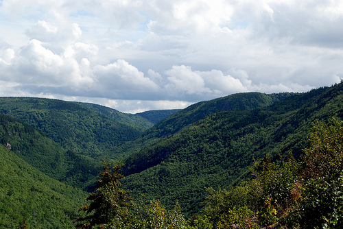
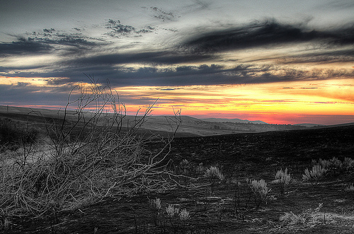
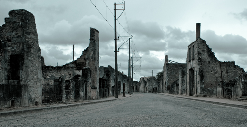
Ashes and Ashes comprises Halcyon Mountain and all lands northward, including the former Bleeding Souls territories, vacated after the 2008 wildfire. Most areas were burned beyond recognition and are still devoid of prey. Some who lived through the fire may recognize their charred former homeland -- others tour the area just to view the damage.
-
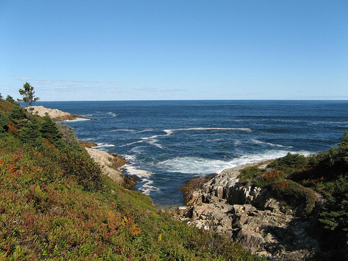
Climate: The climate tends toward cool and wet. Heavy ice build-up in the northern gulf makes for cold winters, though summer can be enjoyably mild thanks to the western strait's warm water flow.
-
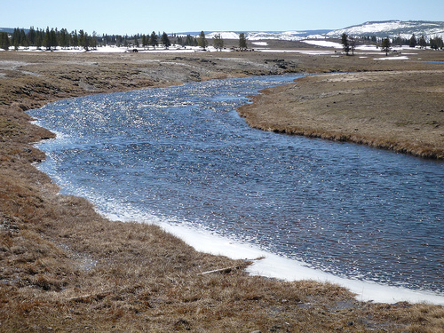
Geography: Most of this region is well-above sea level; the terrain ranges from hilly to mountainous. The land has been irrevocably shaped by the 2008 wildfire; much of the terrain is still recovering. The shoreline is Atlantic; although the water is cold and the waves are strong, the shore lacks the bay coast's extreme tidal range.
-
Demographics: This region was sparsely populated prior to the apocalypse. There is little sign of human occupation outside outside of Sydney and the Aelcrest Shore region. The mountains in particular were unpopulated, and the fire destroyed much evidence of human life further north.
-
Prey: Extremely low numbers in the Withered Realms and The Blacklands; typical populations elsewhere. Small rodents, shorebirds, and the occasional aquatic mammal are the only creatures found in the aforementioned areas.
-
Fauna: Goats, bats, whitetail deer, various rodents, red foxes. Unique animals include the American Marten and the Hooded Seal.
-
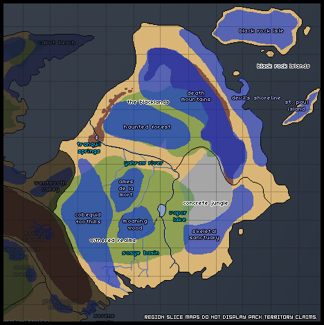
Flora: Halcyon Mountain's underbrush is dominated by Alpine Bilberry and Mountain Cranberry; the forest is mixed, consisting of both coniferous and deciduous trees. In the burned lands, the dominant tree species are paper birch and Quaking Aspen, both pioneer species tending to dominate post-wildfire, along with invasive English Oak. Roman Wormwood is another pioneer plant dominating the northernmost terrain.
- Areas @ 'Souls Wiki: The Wiki has various detailed information about the setting, including landmarks -- particular landforms, buildings, or other very small areas of note -- and past encounters in the area.
- Nova Scotia @ RP Guide: An in-depth guide to the Maritime province of Nova Scotia, Canada.
- Post Apocalypse @ RP Guide: A must-read for players interested in the apocalypse's effects on the world world.
- Travel Guide @ RP Guide: Need help figuring out traveling times and distances? Check this out!
[/html]
[html]
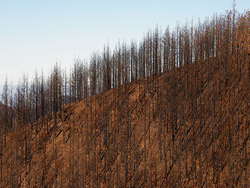
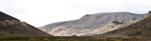
The Appalachian Mountains run through the area, spanning from the far west to the east coast of the lands. The mountains here turn sharply up, reaching at their peak 820 meters. On the northern face of this mountain rock, slides have exposed faults and turned the once-lush forest into nothing more than a rocky cliff. Following the huge forest fire in 2008, this same side of the mountain has turned ash gray and black, covered in soot and dead trees. The Southern side is more fertile, and is densely-forested, home to a multitude of flora and fauna. The northwestern part of the mountain has many jagged cliffs sharp slopes, achieving its maximum height some distance west.
Serene Sands
Halcyon Mountain declines sharply into the forlorn shore of Serene Sands. Located in the southwestern border where land meets the sea, the journey to reach the beach can be difficult due to the craggy ravines that ring the northern part of the area. It is quiet here, save for the gentle lapping of the waves, as the immensity of the mountain blocks out most extraneous noise, keeping the beach serene and tranquil from the goings-on outside. It is quite easy for someone to miss a call from this locale, shielded from interruption, left alone to enjoy the sanctity of the calm waves. During the low tide, many caves hidden deep within the face of the rock become accessible. The series of caves harbour some of the best preserved documents, hand-made trinkets and odd knick-knacks possessed by the pack. Several small and scattered islands become visible a short ways off-shore, under-water hills peaking up from beneath the sea to greet the denizens of the beach. The crowns of these hills are smoothed and slippery rock, making them dangerous to tread upon, and thus a hazard to the curious who would dare to try.
Howling Caverns
Deep in the heart of mountains, resting between two of the larger peaks, lies a set of interconnected caverns that have stood the test of time. There are multiple entrances, some barely large enough for a rabbit, but the most prominent ones are two gaping holes on the rock face nearly fifteen feet high. Just within the mouth of the cave all light disappears and the darkness is absolute. If lit artificially, however, the stone is a pale golden-yellow, rough with crumbling rocks The caves continue on for miles, up as well as down, and it is easy to get lost in the labyrinth. During strong winds, a shrill howl sounds through each of the caves, amongst all the tiny cracks and gaping holes, giving the Howling Caverns its name.
Stellarton Mines
A similar labyrinth can be found in the Stellarton Mines, on the far western end of the mountain. Humans gouged deep into the mountain, creating long and deep tunnels that were in use until the virus struck. Although most of the mine shafts are horizontal, there are a few instances of sharp vertical drops that required the use of elevators--elevators which have long since ceased being used. Of course, there is no natural light in the deeper parts of the mine either. Even with light though, canines are advised to tread very carefully, as a fall into a vertical mineshaft is certain doom -- if the fall itself isn't fatal, there isn't a way back up and out of the mines.
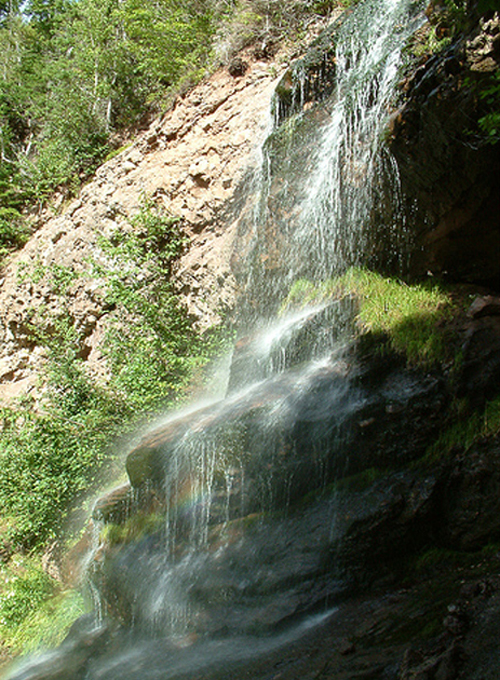
Pictou Falls
The Pictou River runs over Halcyon Mountain, cold and fresh water springing forth from deep within it. During the course of its downstream travel, the river meets a rather sharp cliff face and falls well over fifty feet into a deep pool below, continuing downstream a short way before doing the very same thing. This pattern is repeated four times down the stretch of the mountain, with rolling and rocky cliffs on either side of the waterfall the whole way down. The lowest waterfall is the only one that is safe to jump, as the drop is a mere ten feet and the pool at the bottom is the largest, but the rest are no less picturesque for their danger.
Phosphagos Foothills
At the foot of Halcyon Mountain are what the wolves of the surrounding areas have dubbed "the foothills," or more precisely, Phosphagos Foothills. A series of hillocks lines the base of the mountain, the inclines of each grassy knoll diminishing the further it rests from the base of the great rise. The plant life is fairly uniform in the foothills, tall grasses and small flowers mark the beginning of the ascent up the territory's only mountain range. In the evening, the foothills are overshadowed by the tall trees and mountain itself, thus casting long shadows across the area. Dubbed the 'light-eating' foothills, its name is a rough translation, combining the words 'phos:' light, and 'phago:' I eat.
[/html]
[html]
Aelcrest Shore borders the Northumberland Strait, which separates Nova Scotia from Prince Edward Island. Swift, deadly currents and ice-cold waters swept in from the north prevent the use of current boats (and certainly swimming) across to reach the island; however, anyone stumbling across Aelcrest Shore would find it pristine enough. The shoreline isn't quite so harsh as the bay shoreline, nor so foreboding as the Atlantic Shoreline. Grey Seals make their home along this coastline, providing an ample meal for a Luperci devious enough to catch one. In all months but winter, a few species of whale are found in these waters, using them for breeding in summer. Aelcrest was spared the worst of the fires by the presence of the Cobequid Foothills, and they remain intact, though the odd, rare presence of ash in the easternmost areas show evidence of the fire's reach.
Colchester Quarter
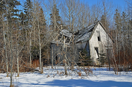
Colchester Quarter, deriving its name from the former Colchester County, does not follow the borders of its predecessor; instead, the area consists of a few small coastal and mountain towns, as well as the semi-wild areas in between. A decaying farmhouse can still be found here and there, but it would seem most were abandoned before humanity's demise. The small towns and communities, on the other hand, were still alive and well in 1988; evidence of construction and other human projects, forever halted, still linger in the ghost towns and villages.
Wentworth Valley
The Wentworth Valley cuts through the Halcyon Mountains and the Cobequid Foothills, formed by a glacier as it cut through the earth and slid toward the sea. Although a few tiny towns once existed within the fertile valley during the time of the humans, they have since fallen to complete ruin -- the only evidence of their existence is the occasional still-standing foundation of a house, or a pile of rotting wood. Some of the trees are bent at awkward angles, and the occasional dead log sits in an impossible place -- speared through boulders at the edge of the valley, for example. At one time after the demise of humanity, a great deluge came through the area, wiping it clean of any evidence of man.
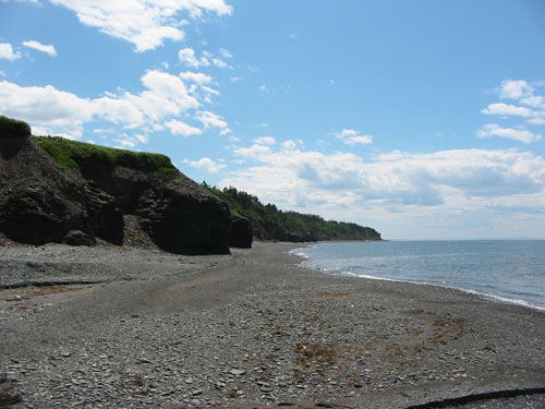
Arisaig Shoal
Once Arisaig Provincial Park, this area displays some of the wild evidence of a young earth. At the top of jagged, low-lying cliffs lining shoreline, there lies a flat surface, evidence of a higher sea level. Arisaig also shows some evidence of glaciation -- the inland areas are rolling hills, marked with kettle indentations and drumlin ridges. The occasional erratic boulder has also come to rest in the Arisaig area, dragged to rest in Arisaig park by glaciers long melted. There is an even mix of grasslands and plains here, and from the shore, one can look to north to the vast island, though the swift currents are certain death for anyone attempting a swim.
[/html]
[html]
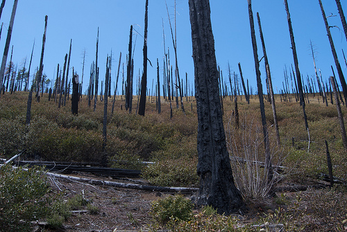
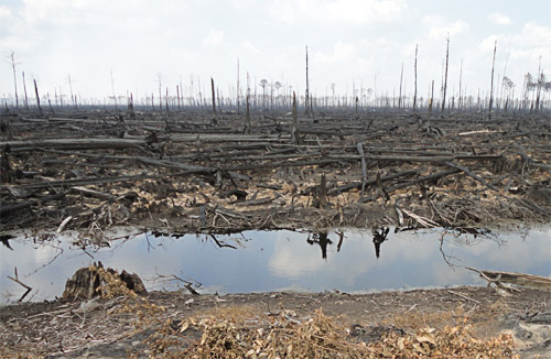
These are the former territories of Bleeding Souls, burned in the 2008 fires. Although there is faint evidence of life returning to this area, the fire was catastrophic, destroying much of the old-growth forests of the area, many of which were completely fire-intolerant. As a result, much of the vegetation was completely decimated and destroyed. Many trees have fallen, though some still remain, dead where they stand. Some greenery and evidence of life shows during the spring and summer months, but even this is sparse and stunted as the area struggles for its recovery. There are few prey animals to be found here -- indeed, it would seem the only animals managing to eke an existence in the burned areas are birds and other small rodents. Nonetheless, it is returning life, however unable to sustain Luperci it is.
The Foothills, formerly a territory of Bleeding Souls, comprised of the low-lying mountains to the north of Halcyon Mountain. In comparison the larger ridge, these are mere rolling hills, though they are gray and foreboding. Stinking sulphur pits, evidence of the long-dormant volcanic activity in the area, comprise what were once kettle lakes and pits, and the area seems overcome with a dense, stinking fog. Even the formerly beautiful Tranquil Springs have become tainted and poisonous to drink from -- any other streams or pools of water in the area are a genuine gamble. The dead and dying remnants of the trees, spared death from the fire but dying a slower one as the land surrounding them seems to die, are steadily withering. Nevertheless, stubborn shrubbery still takes root here between the charred trees -- though they are stunted and gnarled in accordance with their harsh surroundings. Even the birds don't nest here -- the area is devoid of life other than the obstinate shrubs sprouting here and there.
Ames de la Mort
The Âmes de la Mort, stretching south of the Cobequid Foothills to the edge of the Moaning Wood, was once a dead, gray land, littered with dead trees and thirsty dirt. These lands were the initial tinder for the vast wildfire that consumed its surroundings. The territory, once home to the Shadowed Stars pack, had become withered and gray long before the fire; however, in the aftermath, it seems to have fared the best of its surrounding territories. Most of the trees here fell during the initial fire and have begun to rot away; saplings can be seen here, and although the land seems strangely flat and bare, there is evidence of green, returning life. Strangely, however, the predominant settler seems to be the English Oak, which is not native to Nova Scotia. The tree seems to quash its competitors, guaranteeing a forest predominated by the invasive species in several years' time.
Moaning Wood
Often thought to be haunted in the time these territories were occupied, the Moaning Wood has grown no less strange, though its strangeness now lies in silence. The trees, once screaming and creaking, now lie in ruined shambles, blackened logs littering the earth. Here, the fire consumed the trees wholly, and though many of the dead remnants were quick to fall, the abundance of them in this area has smothered much of the potential for new tree growth. However, grass and other low shrubbery has begun to overtake the area, fed by the stream snaking through the territory. In the center of the territory, an unusually clean square is all that remains of the barn once constructed by the packmembers, the wood construction of the building long gone up in flames.
Yawrah River
The territory surrounding the Yawrah River, once green and lush, has become flat and dreary, comprised primarily of floodlands. The trees once lining the river's borders have been swept away, leaving the soil loose and free to erode. Thus, the once quick, clear Yawrah has become muddy and even stinking in the northernmost parts, tainted by the sulfur at its source. However, the clean water from its estuaries is enough to purify it further south -- here, however, the floodplains are even wider, and the river slows to a crawl, dominated by the invasive fanwort plant, another foreign invader to Nova Scotia's soil. Nevertheless, there is still evidence of fish life beneath the surface, and Ospreys and Bald Eagles, fisher-birds, are sometimes seen circling the muddy river, still capable hunters despite the change in the river. Other water-dwelling birds are often seen along the river, though not in any plentiful manner.
[/html]
[html]
The Blacklands
The northeastern most lands of the Cape Breton Peninsula suffered the worst damage from the fire. Years later, the mountainous ridges have kept the beach from prospering, and the land has become even more barren and foreboding. Little plant or animal life is found past the Yawrah River -- canines wishing to trek this way are well-advised to come with their own supplies.
Haunted Forest
The burned ruins of the Haunted Forest are even more forlorn and ghostly. The once magnificent forest is no more; the fire took the trees to their stumps. In addition, terrible flooding later reduced the center of the territory to a boggy lagoon. Around the acrid pit of water, little vegetation has sprouted even in the time since the fire -- with only ashes as fertilizer, there is little chance life will return to this area naturally. The earth remains bleak and gray; a low fog frequently clings to the earth, as it did before the forest was razed.
Death Mountains
The once-proud mountains were shorn bald by the fire, entire forests falling to ruin on them. Logs and other debris rolled downhill, however; in the near future, one is sure to see lush forestation in the valleys and lowlands of the Montagne Orientale. Evidence of this change exists already in the shrubs and saplings thriving on the burned ruin of the old growth.
Devil's Shoreline
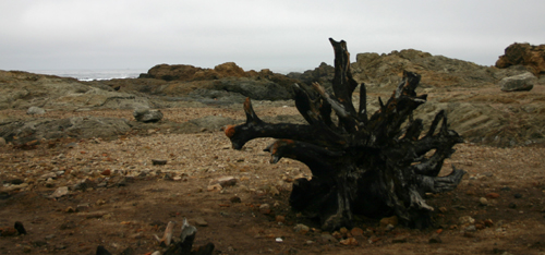
The fire began in Hell's Coast and spread up and down the coast, devouring the sparse, dry vegetation. It has yet to grow back, and the former territories of Hell's Coast and Lightning Bay are bleak and foreboding, lifeless as a desert. The ocean still rages against the sand, seeming to increase with ferocity with nightfall. There is no wildlife to be found on the northernmost coast, save that which comes ashore. Even the seals and birds are quick to depart, however, finding the desolate beach as inhospitable as any canine would.
[/html]
[html]
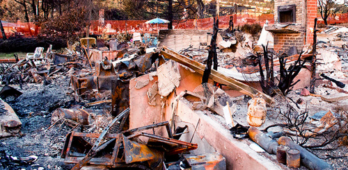
The city did not burn as well as the surrounding forests; nevertheless, char marks and other evidence of fire can be seen clearly in the old city of Sydney. Unlike other human areas, there is very little left to scavenge from this area. Only the raw materials -- the brick and metal of the buildings -- remain. Glass windows melted or shattered from the heat, leaving the city desolate and hollowed. Even the plant life seems to avoid the center of the city; while the old suburbs have begun to show signs of sprouting to forest, downtown remains barren and lifeless.
Skeletal Sanctuary
While the city and its surrounding sprawl were obliviated by the fire, the suburban areas around the city have clearly fared better since. While wild greenery is not seen in the Sanctuary, small shrubs, skinny saplings, and even patchy grass grows here. Most structures have collapsed to their concrete foundations, though here and there, brick and stone fireplaces, chimneys, hearths, and the occasional wooden frames still remain. These eerie, skeletal remnants give the territory its name.
[/html]
|
")
")


